Geospatial services are one of the most important parts of the building’s design infrastructure. The integration of GIS data along with BIM tools gives rise to an all-around safety of the building and its components. When the GIS (Geographic Information system) is incorporated with BIM, it adds a certain geospatial element to the design which makes the system smarter and safer. It enhances the overall workflow of the process.
Role of BIM in the construction processes
BIM has brought immense value to the designing and construction processes that are involved in building formation. The industry has moved from 2D drawings to interactive Revit 3D modeling. Before this, the presence of 2D did not contain so much information but in 3D BIM the amount of information a stakeholder gets is vast.
The integration of BIM with GIS has brought methodical planning in the system which earlier was missing. Both together have played a beneficial role in the industry by bringing a more integrated and organized form of work.
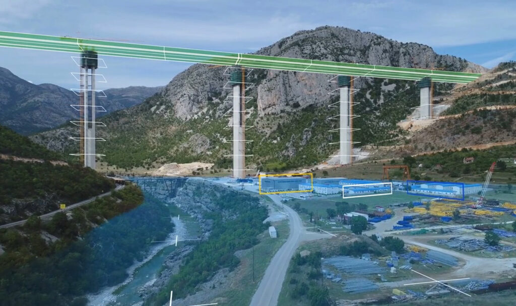
This approach allows introducing a geospatial element to BIM design. This means that construction and infrastructure design companies can plan and put their newly built objects in the matching contexts of their surrounding environment.
In the entire AEC industry, there are a lot of issues regarding data storage. Previously during the procedure of construction, the loss of data used to happen frequently. But this integration with BIM simulation assures consistency in data and safety within the system.
The evolution of both GIS and BIM techniques has been a great boon for maintaining the lifecycle of the buildings and operating the community infrastructure efficiently. Be it transportation modes, roads, or buildings, it is necessary for the geospatial elements to be upright. And to make that right, GIS and BIM help in planning, designing, building, and managing the system well.
BIM and GIS Integration advantages
The process of merging BIM and GIS gives manifold advantages to the stakeholders as well as the building construction process itself. It is a procedure of incorporating the different BIM modeling layers into the geospatial arena. This aids the designers and contractors to make use of precise and accurate details of the area where the construction is going to take place. In case it is situated in a flood-prone area or a rainy location, the materials can be chosen as per that.
The GIS-based information can apply to the different locations throughout different cities, countries, and regions. It also makes a difference while creating a specified item, its shape, and its structure. The BIM and GIS integration helps in forming any kind of object at various levels and scales.
GIS heightens up the project value by adding security to it and upgrading its facilitation with the building design. Below is the list of advantages that the integration procedure gives:
- It allows having a collaborative and comprehensive workflow that helps with the issue of data loss and any other form of errors.
- Allows collection of exact data that further leads to the better project management capacity of the companies.
- It enables the users to get a proper idea of the location and the building environment.
- It gives rise to a better decision-making power with greater efficiency in delivery and operations.
- The building data can be moved around at different stages.
- The management of the system becomes better and the whole project completion takes minimal time.
- The data can be reused whenever the need arises
Thus, we can now understand how the integration of both BIM and GIS technology is beneficial for the construction industry. It makes the whole process much simpler and lessens the time taken for the actual construction.